SR-34 and SR-8
I needed a break... So I booked two nights in St George... I had to get away from the cold and the smog and the snow... So here I am writing this blog post in the business center of the Windgate by Wyndham in St George while my wife is on the treadmill. It was 65 and sunny today and it was AWESOME! I was feeling pretty crappy and thought, "It has been nice and sunny in Salt Lake for nearly a week straight and I didn't get to enjoy it cause I had to sleep all day"... Stupid graveyard shift... I did get one AMAZING day of snowboarding before we came down here, but on the way up to Brighton I got called into work that afternoon which meant I wouldn't see K Jo all night which meant she was feeling pretty lonely which meant I had to go have lunch with her which meant cutting my snowboarding day short... It's okay, I'm going again on Monday. Anyway, so we came down to St George and I thought since I am in St George, I might as well get a state road done. I should also mention that I have decided that instead of Ironman Florida in 2013, I have decided to do Ironman St George in 2012. As I was training one day this winter, it hit me that training for an Ironman during the winter probably wouldn't be nearly as difficult and depressing as I thought it was going to be. I went to Ironman St George's website, and found that registration is still open for 2011, so I should have no problem getting in for 2012. Plus, it will be WAY less expensive with no airfare and no shipping the bike. I looked up the course and it is likely the hardest course in the country with lots of climbing, but you know me... I love me some climbing... This decision also had a small part in our coming to St George this weekend. I am so excited about competing, that I wanted to preview the course so today I rode the big loop that is done twice during Ironman St George, and it is likely that tomorrow I will run the "out" part of the two loop out and back part of the run... I don't think that made any sense... it doesn't matter... I am running tomorrow... Today however, I included SR-8 and SR-34 in my bike ride.


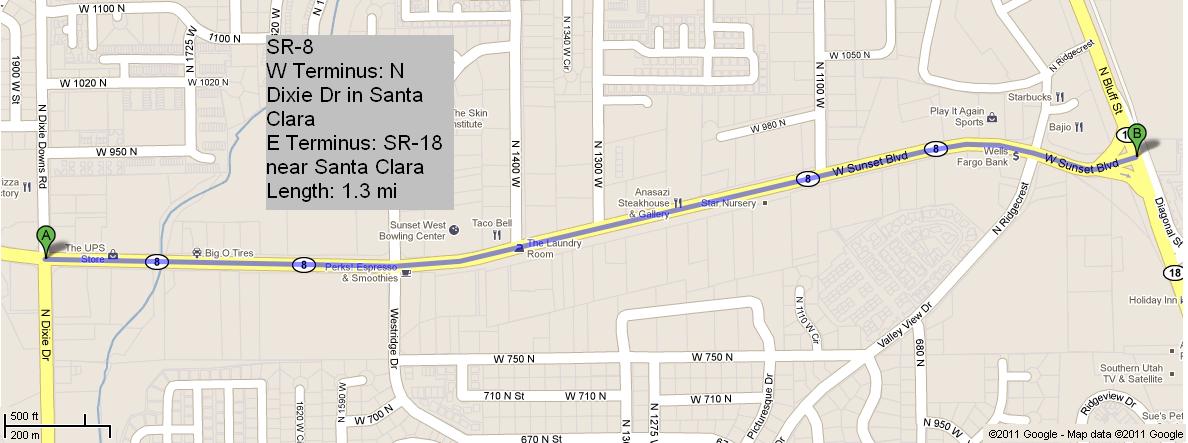
 SR-8 is 1.3 miles of Sunset Blvd in Santa Clara. It begins at N Dixie Dr and ends at SR-18... and it's flat... pretty boring... I did it anyway... I hope you liked the picture of the sign... The blue sky is pretty nice... This one was pretty busy as far as traffic goes, but it has a pretty good shoulder for riding. There was a really nice "end sign" but it was across the street from where I was riding and I didn't want to cross the street just to get a picture.


SR-34 also starts at SR-18 in St George. It is 100 N in St George, aka St George Blvd. This one is also pretty busy in terms of traffic, but it is one of the main thoroughfares of St George so there are a lot of cool businesses along this road. It has a pretty narrow shoulder, but it has a nice wide sidewalk. It terminates on its East end at River Rd. This one is a whole 2.1 miles long... are you impressed? You should be... as you can tell, it is pretty hilly... I rode it backwards, so I was pretty much going downhill the whole time... You don't have to be impressed if you don't want to be. Here is a picture of the "end sign":

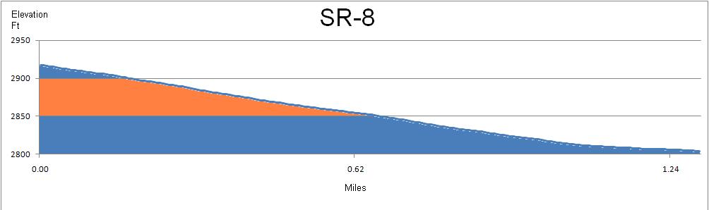
Obviously my ride for the day did not end there. As I mentioned above, I wanted to preview the Ironman St George bike course (which can be found here) so I did the loop from St George to Gunlock, over to Veyo, then back down to St George. If you want to see my ride on a map, you can go here. Technology is so amazing. I love these mapping websites SO SO much. As you can probably tell, the elevation profiles look different. With mapmyride.com, you can map a ride, then save it and it will tell you all of the elevation data which you can export to an excel file and from that, you can make a chart which is basically what constitutes an elevation profile... a simple graph... anyway, with this new discovery, I can work my Microsoft paint magic and make some pretty sweet elevation profiles. When I was done riding SR-8, I continued on the same road which eventually becomes Old Highway 91. It heads out to a really pretty canyon cut by the Santa Clara River as it passes through the Shivwits Paiute Indian Reservation. At the bottom of the canyon, I headed north towards Gunlock Reservoir which was REALLY full due to recent flooding. I then rode through the town of Gunlock. Just outside Gunlock, the road was closed where the river had washed out a portion of the bridge. Luckily, it wasn't closed to bikes, so I continued on. Eventually I hit a hill that is referred to as "the wall". It is 2.6 miles long with an average grade of 3.3%... thank you mapmyride.com... At some points the grade gets up to 15% so it is a pretty tough climb. Just after that climb, I made it to Veyo where I called K Jo and downed a red bull and some jerky. It was then a fast descent into St George along SR-18 which parallels beautiful Snow Canyon. I made my way through St George and back to our hotel room. Such a great day. Today's ride was 60.9 miles. It took me 3:45:58 with an average speed of about 16.2 mph. My top speed was somewhere around 32 mph. I can't be sure... When I stopped in Veyo, my computer FREAKED out and started displaying speeds of 47, 50, 65 mph so I don't really know the top speed. Once I took it off the bike, it went back to normal. These two routes are 21 and 22 for my project. I have ridden 681.2 miles, 246.3 miles of state roads. Thanks for reading.


SR-34 also starts at SR-18 in St George. It is 100 N in St George, aka St George Blvd. This one is also pretty busy in terms of traffic, but it is one of the main thoroughfares of St George so there are a lot of cool businesses along this road. It has a pretty narrow shoulder, but it has a nice wide sidewalk. It terminates on its East end at River Rd. This one is a whole 2.1 miles long... are you impressed? You should be... as you can tell, it is pretty hilly... I rode it backwards, so I was pretty much going downhill the whole time... You don't have to be impressed if you don't want to be. Here is a picture of the "end sign":

Obviously my ride for the day did not end there. As I mentioned above, I wanted to preview the Ironman St George bike course (which can be found here) so I did the loop from St George to Gunlock, over to Veyo, then back down to St George. If you want to see my ride on a map, you can go here. Technology is so amazing. I love these mapping websites SO SO much. As you can probably tell, the elevation profiles look different. With mapmyride.com, you can map a ride, then save it and it will tell you all of the elevation data which you can export to an excel file and from that, you can make a chart which is basically what constitutes an elevation profile... a simple graph... anyway, with this new discovery, I can work my Microsoft paint magic and make some pretty sweet elevation profiles. When I was done riding SR-8, I continued on the same road which eventually becomes Old Highway 91. It heads out to a really pretty canyon cut by the Santa Clara River as it passes through the Shivwits Paiute Indian Reservation. At the bottom of the canyon, I headed north towards Gunlock Reservoir which was REALLY full due to recent flooding. I then rode through the town of Gunlock. Just outside Gunlock, the road was closed where the river had washed out a portion of the bridge. Luckily, it wasn't closed to bikes, so I continued on. Eventually I hit a hill that is referred to as "the wall". It is 2.6 miles long with an average grade of 3.3%... thank you mapmyride.com... At some points the grade gets up to 15% so it is a pretty tough climb. Just after that climb, I made it to Veyo where I called K Jo and downed a red bull and some jerky. It was then a fast descent into St George along SR-18 which parallels beautiful Snow Canyon. I made my way through St George and back to our hotel room. Such a great day. Today's ride was 60.9 miles. It took me 3:45:58 with an average speed of about 16.2 mph. My top speed was somewhere around 32 mph. I can't be sure... When I stopped in Veyo, my computer FREAKED out and started displaying speeds of 47, 50, 65 mph so I don't really know the top speed. Once I took it off the bike, it went back to normal. These two routes are 21 and 22 for my project. I have ridden 681.2 miles, 246.3 miles of state roads. Thanks for reading.

Comments
Post a Comment